SuccessStory.SuccessStory

EO Service for mapping of long term trends in deforestation in tropical regions
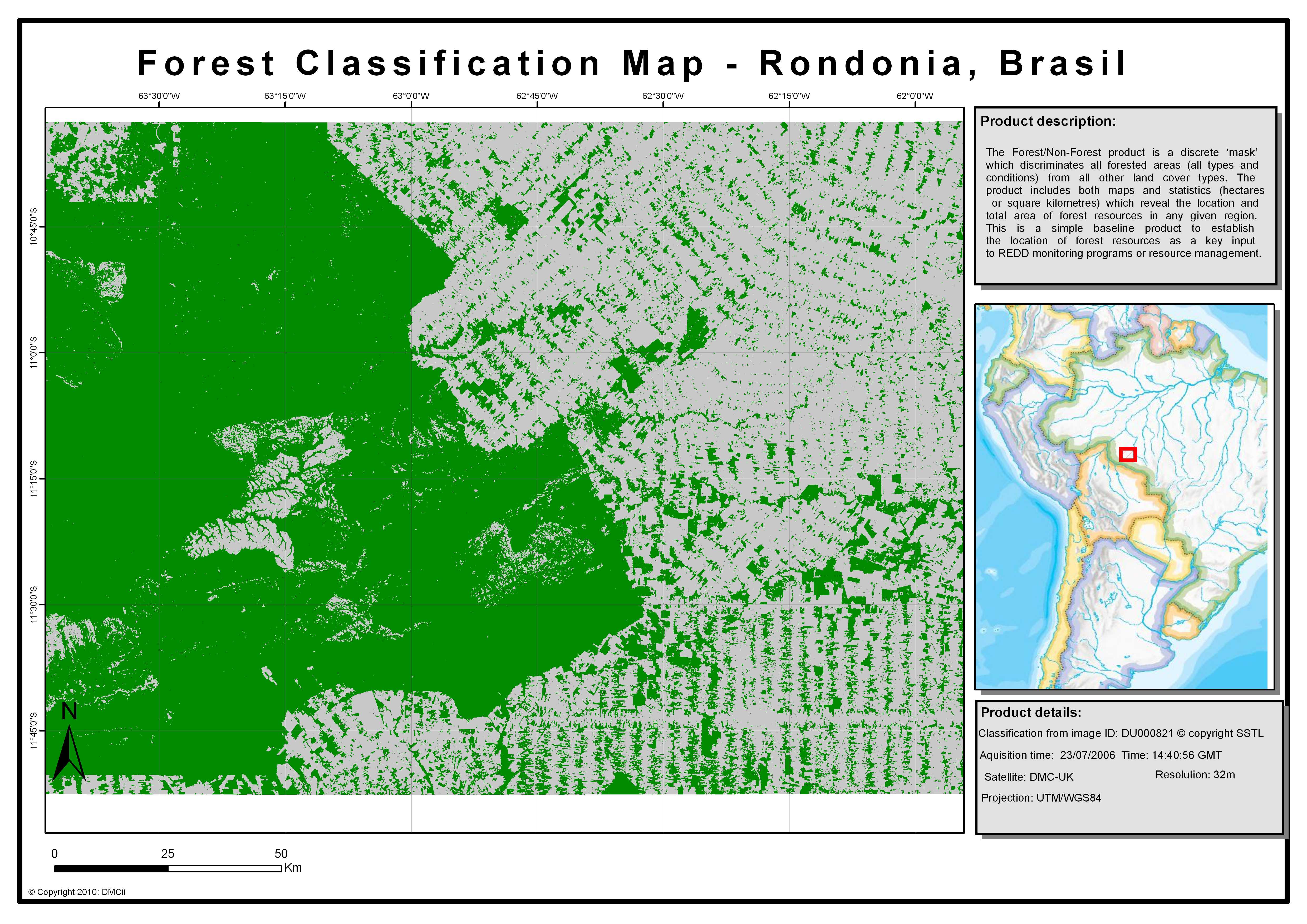
Forest classification maps_Rondonia.jpg

SuccessStory.Intro

DMCii supplies the Brazilian National Institute for Space and Research (INPE) annually with high resolution satellite imagery coverage of the Amazon Basin. INPE uses DMC satellite imagery to estimate Amazon Basin deforestation. The imagery campaign focuses on achieving a full coverage in short imaging windows to achieve homogeneity of data for analysis.

SuccessStory.BackgroundProject

Between May 2000 and August 2006, Brazil lost nearly 150,000 square kilometres of forest - an area larger than Greece - and since 1970, over 600,000 square kilometres (232,000 square miles) of Amazon rainforest have been destroyed. The main sources of deforestation in the Amazon Rainforest are human settlement and development of the land. Most of the forest loss has been replaced with pasture for cattle.

SuccessStory.IssueAndNeeds

One of the major concerns arising from deforestation is the global effect on climatic change. The rainforests are of vital importance in the carbon dioxide exchange process, and are second only to oceans as the most important carbon sink on the planet to absorb increasing atmospheric carbon dioxide resulting from industry. It is essential to protect these areas and monitor changes that take place.

SuccessStory.ProposedSolution

Remote sensing is acknowledged as the best solution for forest monitoring of such vast areas. INPE is a research unit of the Brazilian Ministry of Science and Technology, whose main goals are fostering scientific research and technological applications and qualifying personnel in the fields of space and atmospheric sciences, space engineering, and space technology. It developed the PRODES project for a detailed annual assessment of deforestation. PRODES, one of the actions of the Science and Technology Ministry (MCT), in the Plan of Prevention and the Amazon Deforestation Control (PPCDAM), has been recognized as an essential contribution for the PPCDAM goals as well as for transparency in publishing the information about the Legal Amazon. INPE makes PRODES information freely available through: www.obt.inpe.br/prodes Making use of high resolution optical satellite sensors, PRODES enables the capture of all deforestation bigger than 6.26 hectares.

SuccessStory.IndustryPerspective

DMCii is one of the data suppliers for the project. DMC wide swath images can cover huge areas and they reduce the time of the analysis significantly. In 2005 DMCii delivered full coverage of the entire Legal Amazon with 32m gsd. Since then DMCii has been able to provide reliable annual large area coverage, and multi-temporal coverage of high risk areas. For example, in 2010 DMCii delivered two coverages of the Southern Arc of the Amazon Basin (Brazil) - one for July-August and second one for August-September - made up of 110 images with relatively low cloud cover for this region. Since CBERS reached end of mission and with intermittent Landsat 5 supply, DMC imagery has provided a reliable core of the monitoring programme.

SuccessStory.ServiceProvider
SuccessStory.UserCustomer
Brazilian National Institute Space Research (INPE)
SuccessStory.Source
DMVii
services

Related Content

Groundstation Direct Imagery Download Licensing
Detect illegal or undesired crops, Agriculture, Measure land use statistics, Detect & monitor land movement, uplift, subsidence, heave., Construction, Detect and monitor wildfires, Emergency Services, Map and assess Flooding, Assess Deforestation / Degradation, Forestry, Detect and monitor wildfires, Monitor forest resources, Detect and monitor wildfires, Insurance and Finance, Map and assess Flooding, Detect & monitor land movement, uplift, subsidence, heave., Local and regional planners, Detect & monitor land movement, uplift, subsidence, heave., Minerals and Mining, Measure land use statistics, Transport, Assess changes to urban and rural areas, Utilities, Assess environmental impact of farming, Assessing crop damage due to storms, Monitor crop disease and stress, Assess crop acreage and yield. Harvest, Monitor specific crops types, Forecast crop yields, Monitor water use on crops and horticulture, Measure soil water index, Assess environmental impact of human activities, Assess damage from industrial accidents, Forecast and assess landslides, Forecast crop yields, Enviroment, Pollution and Climate, Assess environmental impact of human activities, Map and assess Flooding
22m multispectral UK-DMC2 data is available to download to existing and new ground stations for immediate use to support projects and applications. DMCii provides turnkey solutions for the complete ground segment infrastructure required to retrieve, process, store and analyse all imagery. Both hardware and software can be installed and commissioned at the site of your choice to achieve full operational functionality.
Satellite Imagery
Assess environmental impact of farming, Agriculture, Assessing crop damage due to storms, Monitor crop disease and stress, Assess crop acreage and yield. Harvest, Monitor specific crops types, Forecast crop yields, Detect illegal or undesired crops, Monitor water use on crops and horticulture, Measure land use statistics, Monitor high risk areas, Education, training and research, Assess environmental impact of farming, Enviroment, Pollution and Climate, Assess changes in the carbon balance, Assess climate change risk, Measure land use statistics, Assess changes in the carbon balance, Forestry, Assess Deforestation / Degradation, Detect and monitor wildfires, Assess forest types, Monitor forest resources, Detect illegal forest activities, Assess environmental impact of forestry, Assessing forest damage due to storms or insects, Monitor high risk areas, Local and regional planners, Assess changes to urban and rural areas, Monitor high risk areas, News and Media, Monitor high risk areas, Real-estate management, Monitor high risk areas, Retail and geo-marketing, Monitor high risk areas, Security, Defence and military
High and Very High Resolution Satellite Imagery. Rapid revisit, time series and long-term mapping imagery for agriculture, cartography, change detection, telecomms and all other applications.
Mapping long terms trends in deforestation
Assess Deforestation / Degradation, Forestry, Assess forest types, Monitor forest resources, Detect illegal forest activities, Assess environmental impact of forestry
Provide annually high resolution satellite imagery coverage to estimate areas of deforestation. The imagery campaign focuses on achieving a full coverage in short imaging windows to achieve homogeneity of data for analysis.
Imagery Processing Services
Detect illegal or undesired crops, Agriculture, Measure land use statistics, Detect & monitor land movement, uplift, subsidence, heave., Construction, Detect and monitor wildfires, Emergency Services, Map and assess Flooding, Detect and monitor wildfires, Insurance and Finance, Map and assess Flooding, Detect & monitor land movement, uplift, subsidence, heave., Local and regional planners, Detect & monitor land movement, uplift, subsidence, heave., Minerals and Mining, Measure land use statistics, Transport, Assess changes to urban and rural areas, Utilities
Orthorectification, colour balancing, batch imagery processing. Expertise in diverse data type analysis to customer requirements.