Erfolgsgeschichte
A TRE case study reservoir monitoring with INSAR (Middle East Oil Field)

SuccessStory.Intro
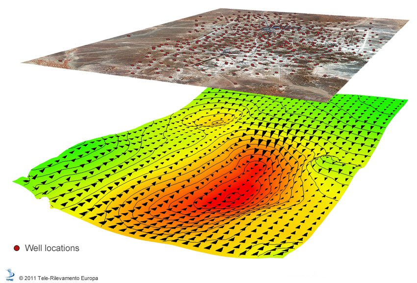
Surface deformation monitoring can provide valuable information about the dynamic behaviour of reservoirs under production. Measuring these deformations can help to identify undepleted compartments, detect fault reactivation, mitigate risks associated with well failure, constrain geomechanical models, and aid field management decisions. We have demonstrated that satellite InSAR is a powerful tool to measure surface movement and is useful for managing reservoirs under production. SqueeSAR™ is the latest InSAR algorithm developed by TRE. The InSAR analysis covers a stacked carbonate reservoir in the Middle East. The top reservoir is a mature gas with a depth of approximately 750 m, which is known to compact. The lowest reservoir is an oil reservoir with a 1200 m depth produced by a water-flood. Both reservoirs are intersected by a major graben fault, trending NE-SW, as well as numerous additional extensional faults. Approximately 500 producer and injector wells have been drilled in the area. A comparison with existing GPS measurements has shown a good agreement between InSAR and GPS data. We have also inverted InSAR data using a geomechanical model to obtain reservoir strains. These compare well with pressure change maps from reservoir simulations. There is also an intriguing correlation between known fault systems at the reservoir level and the surface displacement data by satellite InSAR. Figure 1 Ground surface response to hydrocarbon extraction. Red circles represent the surface coverage of extracting wells. Arrows indicate horizontal surface movement (East-West).
SuccessStory.BackgroundProject
Surface deformation monitoring can provide valuable information about the dynamic behaviour of reservoirs under production. Measuring these deformations can help to identify undepleted compartments, detect fault reactivation, mitigate risks associated with well failure, constrain geomechanical models, and aid field management decisions. We have demonstrated that satellite InSAR is a powerful tool to measure surface movement and is useful for managing a reservoir under production.
SuccessStory.IssueAndNeeds
Consistently updated information about surface subsidence and contraction over oil fields is required to efficiently manage the operation.
SuccessStory.ProposedSolution
One ascending (Envisat satellite) and one descending (RADARSAT-1 satellite) datasets were acquired during the period 2004–2007. Envisat is comprised of 20 images acquired with a 35-day repeat pass, while Radarsat-1 is comprised of 34 images acquired with a 24-day repeat pass. Combining the double geometry datasets, the vertical and horizontal components of surface deformation can be calculated with SqueeSAR™. A comparison with existing GPS measurements from permanent and rover stations has shown a good agreement both for the vertical and horizontal components. This suggests that SqueeSAR™ is suitable for monitoring surface deformation changes with high accuracy. By comparing InSAR data with the known faults at reservoir level, an intriguing correlation is evident between the known fault system and the gradient of the subsidence field.
SuccessStory.IndustryPerspective
Surface deformation monitoring can provide valuable information about the dynamic behaviour of reservoirs under production. Compacting reservoirs induce surface subsidence, as well as contraction. Measuring these deformations can help to identify undepleted compartments, detect fault reactivation, mitigate risks associated with well failure, constrain geomechanical models, and aid field management decisions.

