SuccessStory.SuccessStory
Validating Space Observations for Flooding with Crowdsourcing In-Situ Observations

SuccessStory.Intro
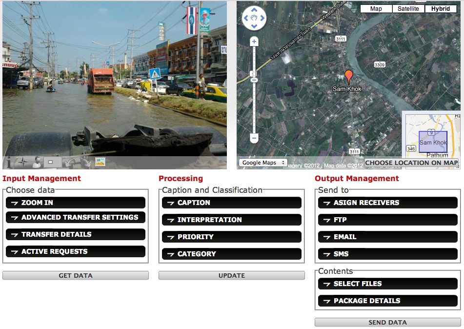
In the framework of the FP7 SPACE Project GEO-PICTURES, AnsuR and United Nations (UNOSAT) collaborated on using a smartphone App for crowdsourcing geo-referenced in-situ images for the purpose of improving flood assessment from Radar EO Images. The approach was a great success and has lead to initiatives with Statoil for using the same approach for improved Environmental Monitoring within the Oil and Gas industry.
SuccessStory.BackgroundProject
During the 2011 monsoon season in Thailand, severe flooding occurred. Over 800 people died, 77 provinces were declared disaster zones and the world bank estimated the total cost approaching 50 billion USD, ranking it as the 4th most costly disaster in the world. The flood lasted close to 6 months, from July 2011 to January 2012. Close to 15 million people were directly affected. In order to prevent further damages, accurate monitoring of the extent of the flood was required, and UNOSAT provided periodically updated flood maps based on using radar satellite images every few days for a period. The flood maps were offered publicly. Both the Thai government, the Asian Disaster Prevention Center (ADPC) and Google.org used them in their disaster management. When the flood approached the larger cities, and specifically Bangkok, a larger disaster was possible. More frequent and more accurate flood predictions were needed than in the rural areas, as much more was at stake.
SuccessStory.IssueAndNeeds
While the importance of up-to-date monitoring of the flooding in the city areas increased, the quality of the radar observations was reduced due to increased backscatter from objects and infrastructure in the urban areas, making it very difficult under a flood with rainy conditions daily to determine if an area was flooded or if reflections were just from wet surfaces like a motorway. In a satellite radar image, the intensity of each pixel represents the proportion of microwave backscattered from that area on the ground which depends on factors like types, sizes, shapes and orientations of the objects providing scatter in the target area as well as the moisture content, frequency, radar polarization and incident angles of the radar beam.
SuccessStory.ProposedSolution
This makes interpreting a radar image not a straightforward task. It very often requires some familiarity with the ground conditions of the areas imaged. In-situ observations and validations become essential. This can be done best using geo-referenced photos, and make them available to the experts interpreting the satellite images in close to real time. Bot how does one get access to a large set of in-situ photos over such a long duration as a 6-month flood? UNOSAT sent a team to observe the situation and provide geo-referenced field photos in order to validate the satellite observations. However, they could not remain in Bangkok for more than a week, and travelling around was very difficult. Thus, the professional field photos were taken in a limited geographical area and over a limited time. More photos were needed over a larger area and over a longer time. Via the collaboration between AnsuR and UNOSAT in the FP7 SPACE project GEO-PICTURES we found a better solution.
SuccessStory.IndustryPerspective
AnsuR has for many years worked with efficient communications of geo-tagged pictures, commonly using traditional cameras and a specialized smartphone application as a tool for communicating photos quickly and reliably. Over in May 2011, a few months before the flooding started, AnsuR released a Crowdsourcing version of the ASIGN application for UNOSAT at the GDACS stakeholder meeting in Bergen, Norway. This tool was meant for use of people associated with UN. However, AnsuR suggested during the Thai floods to release this application for the public in Thailand, in order to provide input to the validation of satellite images as well as allow other use of the images that were input.


